
Directions to Puerto Penasco (Rocky Point)
How to Reach Puerto Penasco (Rocky Point) from diverse US localities
If you are just about to go to Puerto Peñasco, the first thing you want to is to start finding direction to those specific hotels or resorts that you would like to visit. This page is for those who are specifically looking for directions. Don’t get lost, simply visit Rocky Point Maps Sections and you will get the map to lead you.
Please visit the car rental page if you are searching for a car rental
It is recommended that you download our exhaustive map which shows the locations of various restaurants before we start with the directions. Although businesses are constantly changing, we try to keep the map updated. Click here to download the latest map with restaurants.
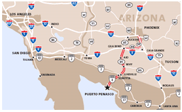
If you are looking for details map that show step by step directions from different regions of the Western United States, then you will find these maps to be very important. The maps offer detailed directions that you won’t find in ordinary maps.
The list below contains the appropriate maps with directions.
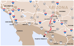
East Phoenix
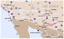
California
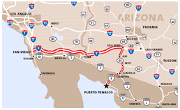
West Phoenix
We know that the directions are not always perfect that is why we strive to offer additional driving information. You are free to choose the directions that you feel will get you to your destination. Here are some of the additional directions that you might want to consider:
From Phoenix
- Take the 1-10 wet to the end of the town—to State Highway 85 South (Buckeye Area).
- Proceed with Highway 85 and go straight till you reach Gila Bend. Remember, you are using the same Exit as 1-8 San Diego
- Once you reach the end of the Gila Bend you will be able to see one of the Mc Donald’s. Before you reach the MC Donald’s, turn on to the continuation of Highway 85 South. It is about 90 minutes’ drive before you reach the border.
- Just follow the highway 85 straight till you reach Mexico. You will have to make two turns before you arrive at Sonoyta. Overhead, you will see signs that point to Peñasco, commonly known as Rocky Point, which you are supposed to follow.
- You will drive for about 60 more miles before getting to your destination.
From Tucson
- Valencia Road is the largest street in Tucson that has come to be known as Highway 86(also known as Ajo Highway) which leads to the West. Take the 1-10 to 1-9 South. It is important to note that you will only be on the 1-19 (Ajo Exist) for about one mile.
- While on Highway 86, continue westwards for about two hours thirty minutes until you reach a town called Why. You will pass through Sells and Quijotoa which are found on the Indian Reservation known as Tohono O’odham.
- When you reach Why, turn left to the State Highway 85 and continue with the highway till you arrive at the Mexican Border, Lukeville.
- Just across the Mexican/U.S border is a Mexican town called Sonoita. If you stay on the right, you will see signs that will guide you through the town until you reach Puerto Penasco.
- Just remain watchful for them. You will be placed on the Mexico route 8 and you will go straight to Puerto Penasco, the Rock Point. You have to stay alert because there are a few sharp turns. It is recommended that you only drive during the daytime to avoid getting lost.
From Los Angeles
- You should take the Interstate 10 East Highway and head to the Buckeye town, Arizona.
- Then go South on State Hwy 85 over the towns of Gila Bend then to AJo then to Why in that order. Proceed until you reach the Mexican Border at a place called LukeVille.
- Just across the Mexican/U.S border is a Mexican town called Sonoita. If you stay on the right, you will see signs that will guide you through the town until you reach Puerto Penasco.
- Just remain watchful for them. You will be placed on the Mexico route 8 and you will go straight to Puerto Penasco, the Rock Point. You have to stay alert because there are a few sharp turns. It is recommended that you only drive during the daytime to avoid getting lost.
From San Diego
- You should take the Interstate Highway 8 East, proceed through the Yuma bordwertown, Arizona and go straight to Gile Bend town.
- Then go South on State Hwy 85 over the towns of Gila Bend then to AJo then to Why in that order. Proceed until you reach the Mexican Border at a place called LukeVille.
- Just across the Mexican/U.S border is a Mexican town called Sonoita. If you stay on the right, you will see signs that will guide you through the town until you reach Puerto Penasco.
- Just remain watchful for them. You will be placed on the Mexico route 8 and you will go straight to Puerto Penasco, the Rock Point. You have to stay alert because there are a few sharp turns. It is recommended that you only drive during the daytime to avoid getting lost.
What is the alternative route from Yuma into Mexico onto Peñasco
You may want to reach Pensco town from Yuma if you are coming from the West. If so, you can drive through the Yuma town and across the U.S/Mexico border and take another route that will involve additional driving in Mexico. Take the 95 south from Yuma through Somerton to San Luis at the border. From there, you can proceed to Sonora and then go east until you arrive at 8 in Sonoyta. From there, you can go on to Penasco on the 8. It is important to note that this route will take you round the north tip of Pinacate and through the mountain formations.